
StrikOreStrikOre

看得全,
说得清依据
See it all.
Show the evidence.

判据库、地质数据库、可审计的算法与项目工作台——以及它交付给地质团队的东西。首版以遥感为首个重点方向,计划 2026 年 12 月开放。The criteria library, geological database, auditable algorithms and project workbench — and what they deliver to your team. The first release leads with remote sensing and is planned for December 2026.

01

判据库Criteria library

把全球矿业专家在各国、各矿种、各成矿环境中的找矿方法一条条收进来,标注来源、适用范围,以及被现场证伪的记录。每一次专家复核,都让它更懂这一类矿。Exploration methods from experts across countries, commodities and ore-forming settings, captured one by one with their source, where they apply and where the field proved them wrong. Every expert review makes it understand that kind of deposit better.

021000+

可审计的算法Auditable algorithms

不训练通用大模型——没有两个相同的矿床。把找矿拆成可执行、可回放的 Harness 工程节点,已建成 1000 余个;证据图谱让每项结论回溯到源文件、坐标与版本。No general-purpose model — no two deposits are alike. Exploration is broken into more than 1,000 executable, replayable Harness engineering nodes, and an evidence graph traces every conclusion back to its source file, coordinates and version.

03500TB+

地质数据库Geological database

超过 500TB 的地质数据,报告、图件、物化探、钻孔与遥感成果统一入库,按项目检索、引用与版本管理。More than 500 TB of geological data — reports, maps, geophysics, geochemistry, drilling and remote-sensing products — stored, searched, cited and versioned per project.

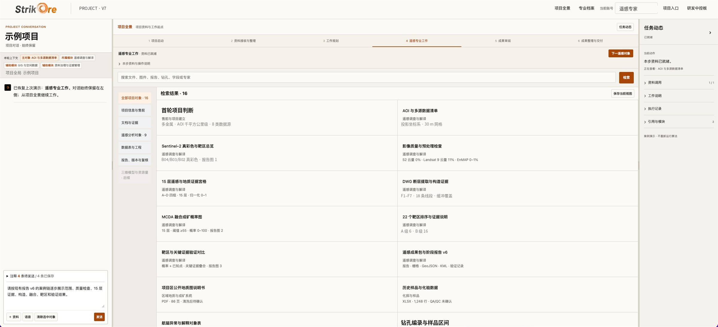
StrikOre 系统项目全景检索界面
StrikOre 项目工作台 · 项目全景:六段式作业流与资料证据索引 · 界面已脱敏StrikOre project workbench · overview: six-stage workflow and evidence index · redacted
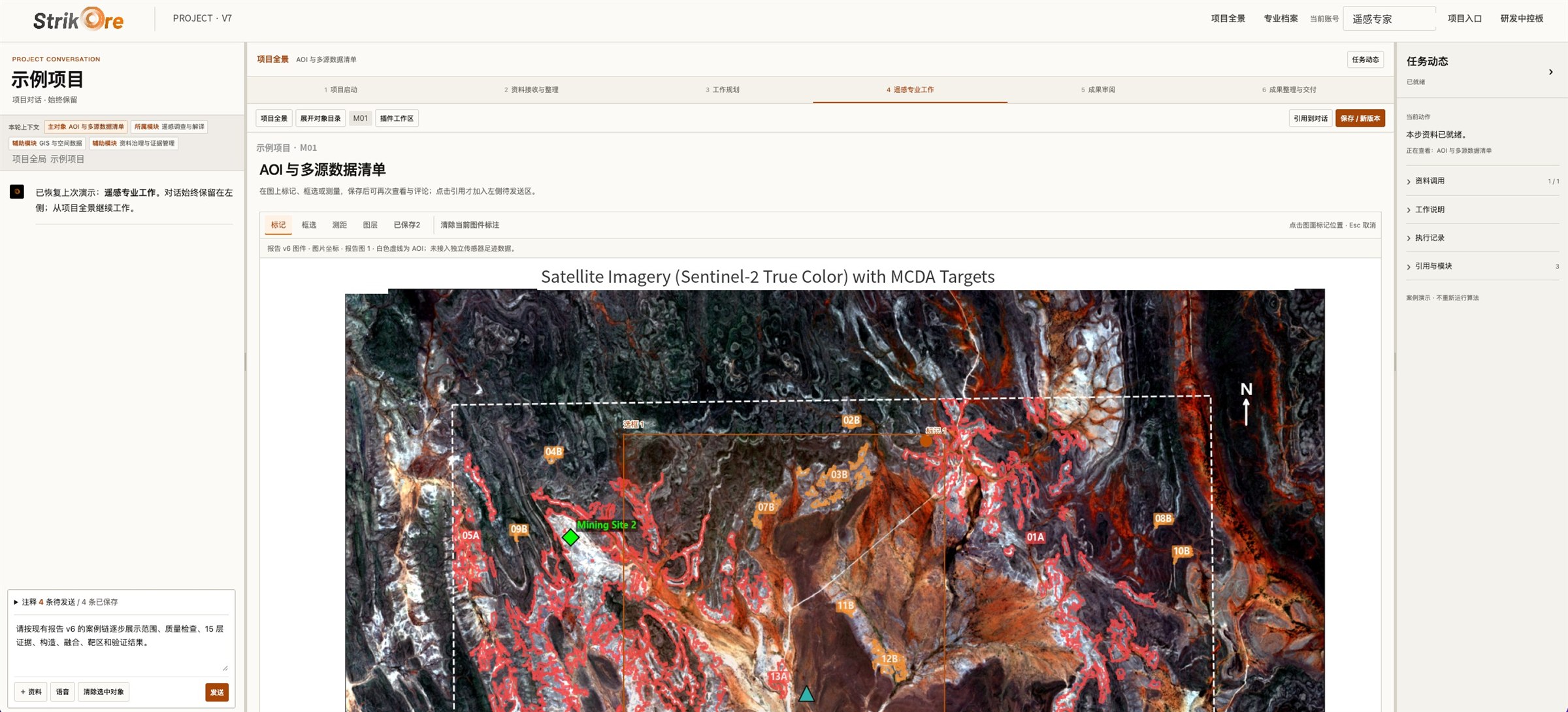
StrikOre 系统遥感工作区界面
StrikOre 遥感工作区 · 多源数据清单与潜力区图件 · 界面已脱敏StrikOre remote-sensing workspace · data inventory and prospectivity maps · redacted

资料清单Data checklist

资料类型Data type 常见形式Typical form 要求与说明Notes
矿权边界 · 矿种Licence · commodity拐点坐标corner coords矿权证licence目标区域坐标、目标矿种,含已知伴生元素Target area coordinates and commodity, including known associated elements
区域地质图Geological maps1:10k1:50k1:100k1:200k比例尺越大越好,1:1 万最佳Larger scale is better — 1:10,000 ideal
报告与文献Reports & literaturePDFDOCX扫描件scans地质、勘查、科研报告,论文,邻近矿区报告Geological, exploration and research reports; papers; neighbouring projects
航磁 / 航放Airborne mag / radΔTRTPK · eU · eThU/Th磁异常、化极、梯度与放射性元素比值Magnetic anomaly, reduced-to-pole, gradients and radiometric ratios
物探 / 化探Geophysics / geochem电法EM / IP磁法magXLSX测点坐标与数值,采样化验结果,QA/QC 状态单独标注Station coordinates and values, assays, QA/QC status flagged
钻探资料Drilling孔位collars测斜surveys编录logs化验assays包括未见矿的钻孔Including holes that missed
遥感影像Remote sensingSentinel-2Landsat 9EnMAPSARDEM多光谱、高光谱、雷达与高程数据,先做云量与质量检查Multispectral, hyperspectral, radar and elevation data, cloud- and quality-checked first
踏勘记录Field records照片photos采样samples探槽trenches岩石、土壤、水系采样,探槽剖面,民采坑位置Rock, soil and stream samples; trench sections; artisanal workings

资料不全也可以开始。启动只需要矿权范围坐标、目标矿种和现有资料清单;公开资料和遥感适合早期筛选,但不能替代原始数据和现场验证。Incomplete data is fine to start with: licence coordinates, commodity and a list of what you have. Public data and remote sensing suit early screening but never replace raw data and field verification.

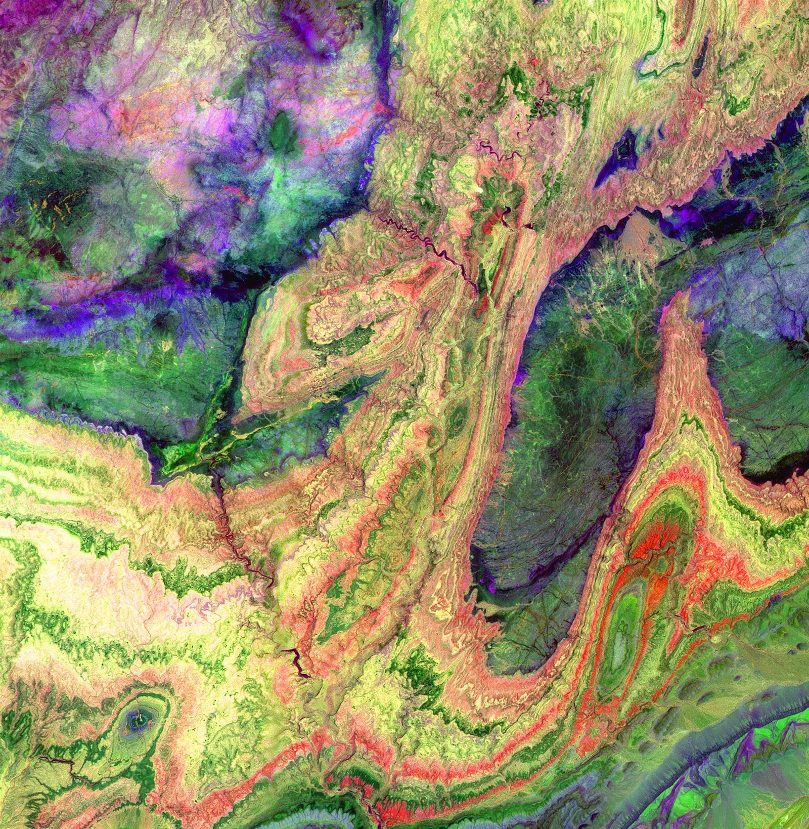
ASTER 多光谱影像中的摩洛哥反阿特拉斯山褶皱地层

交付成果Deliverables

结论在前,
证据链在后
Conclusions first.
Evidence behind them.

报告结论前置,后附支撑数据、完整证据链、权重表、潜力区热区图、风险点和后续推进路线,白盒可审,可分模块由专家修改。Conclusions up front, followed by supporting data, the full evidence chain, weighting tables, prospectivity heat maps, risks and next steps. A white box, reviewable and editable module by module.

ANTI-ATLAS, MOROCCO · NASA / JPL ASTER

潜力区说明 · 虚构示例Prospective-area sheet · fictional example

P-03 优先级 APriority ACu虚构示例Example
面积Area2.4 km²
证据层命中Layers hit6 / 11
资料等级Source gradeA · B

支持证据Supporting

  • NE 向与 NW 向断裂交汇部位Intersection of NE- and NW-trending faults · 构造解译· structure
  • 铁染 + 泥化蚀变异常连片分布Contiguous iron-oxide and argillic alteration · 遥感· remote sensing
  • 水系沉积物 Cu、Mo 异常,下游方向吻合Stream-sediment Cu–Mo anomaly, consistent downstream · 化探· geochemistry

矛盾或缺失Contradicting / missing

  • 航磁在南段无明显响应No clear magnetic response in the southern part
  • 历史化探 QA/QC 记录缺失,含量值仅作参考Historic geochem lacks QA/QC records — values indicative only

未经证实的假设Open assumptions

  • 按斑岩型铜矿模型解释蚀变分带,尚无钻孔支持Alteration zoning read as porphyry-Cu model; no drilling support yet

随报告交付Delivered with the report

PDF

遥感专项报告Remote-sensing report

蚀变信息图、矿物识别分布图、裂隙玫瑰图、波段比值图等专题图件,逐图说明Alteration, mineral-distribution, fracture-rose and band-ratio maps, each with its explanation

GeoTIFF

证据层与成矿概率图Evidence layers & prospectivity

各证据层与加权融合结果,保留权重配置Each layer and the weighted fusion, with the weights used

GeoJSON · KML

潜力区矢量Prospective-area vectors

潜力区范围与分级,可导入你们的 GISOutlines and ranking, ready for your GIS

TRACE

验证记录Verification record

每条结论引用的资料、处理步骤与版本Sources, processing steps and versions behind every conclusion

综合分析报告的四个部分Four parts of the integrated report

I

综合信息提取与整合Information extraction & integration

地层岩性、区域演化、控矿构造、岩浆与流体、蚀变矿化、化探异常,归纳找矿模型Stratigraphy, evolution, ore-controlling structures, magmatism, alteration, geochemistry — an exploration model

II

不一致观点识别Conflicting interpretations

前人资料在构造归属、成矿时代等方面的分歧,以及如何解决Where prior work disagrees, and how each conflict is resolved

III

易被忽视的潜在价值Overlooked potential

重新判断矿床类型,挖掘被覆盖或被忽视的勘查线索Re-examining deposit type and surfacing overlooked leads

IV

综合研判与部署建议Assessment & next-phase program

成矿条件评价、矿化类型排序、优先验证方向与关键风险Metallogenic assessment, ranked styles, priority areas and key risks

从一个矿区开始Start with one district

ken@strikore.com

Try StrikOre

StrikOre 首版即将开放StrikOre opens soon

StrikOre 首版计划于 2026 年 12 月开放,以遥感为首个重点方向。想第一批试用,发邮件告诉我们你们的团队、项目阶段和矿种。The first release of StrikOre is planned for December 2026, leading with remote sensing. To be among the first users, email us your team, project stage and commodity.

PLANNED · 2026.12